Contributions of the HOUGHTEAM to modern geodesy
During the spring of 1945, as Allied forces closed in on Berlin, members of a special U.S. military unit discovered a large cache of geodetic material in a remote warehouse in Saalfeld, Germany. These archives contained almost complete coverage of all orders of geodetic control data for the German occupied areas of Europe, 95 percent of which had not been previously available to the Allies. Weighing in at just over 90 tons, it is considered to be the largest coup in the history of geodesy.
A special unit of the military intelligence division, Office of the Chief Engineers (OCE), operated in the European theater from October 1944 to September 1945. Its mission was the exploitation of targets for the procurement of geodetic control and maps. The team was known as the HOUGHTEAM, named after their scholarly leader, U.S. Army Major Floyd W. Hough. The complement consisted of three commissioned officers, four engineer consultants and 10 enlisted men. The HOUGHTEAM operated freely throughout the European Theatre of Operation (ETO) and had no Table of Operations and Equipment (TO&E), nor was it attached to any Army group.
Early in the year 1944, it became evident to OCE that a significant deficiency existed in the holdings of geodetic horizontal and vertical control, as well as source materials required for military mapping operations. This deficit was specific to Europe, especially the Balkans. Much of Europe had no geodetic data publicly available except that of first-order control, which was entirely too sparse to serve the needs of adequate, large-scale topographic mapping required in ETO. In every country, thousands of such known geodetic points exist and are normally documented by the national mapping agencies.
In geodesy and surveying, a control network, or simply control, is a set of reference points of known geospatial coordinates. The higher-order (first order) control points are normally defined in both space and time using global or space techniques, and are used for “lower-order” points to be tied into. The lower-order control points (second and third) are normally used for engineering, construction and navigation. The scientific discipline that deals with establishing the coordinates of points in a high-order control network is called geodesy, and the technical discipline that does the same for points in a low-order control network is called surveying.
Classically, a control is divided into horizontal (X-Y) and vertical (Z) controls (components of the control); however, with the advent of satellite navigation systems, GPS in particular, this division is becoming obsolete.
Hough wrote that “the war in Europe offered a unique opportunity to exploit known targets and thus to procure from enemy sources captured material of this type both for immediate use of artillery units and for preparation of operational maps.”
In September 1944, Hough, chief of the geodetic branch, military intelligence division, OCE, was directed to organize the team and to proceed without delay to ETO.
October 23, 1944, the HOUGHTEAM arrived in Paris. An office was quickly established in that city and research work started among the various local libraries. Portions of the team operated on the battlefront in such locations as Germany and France, with arrival time on the day that it was being cleared of enemy troops. At various times during this period, other portions of the team were sent for geodetic and map research work to such places in the ETO as Lyon, Marseille, Rome, Pisa, Florence, Foggia, Naples, Lisbon, and Brussels.
In the spring of 1945, the HOUGHTEAM picked up and relocated into Germany, arriving in Frankfurt March 29. In the five months since its formation, the HOUGHTEAM produced a large amount of captured geodetic material vital to the artillery for the provinces of Baden-Baden, Württemberg and Bavaria. During World War II, artillery batteries typically employed “indirect fire” techniques, whereby the firing equipment was aimed without seeing the target through its sights. Precise distance measurements were paramount for this type of technique to be effective. The HOUGHTEAM’s data captures were rushed directly to the survey officers of the third and seventh armies, in time for use by their artillery units in battle.
Hauptader – “Mother Lode”
Rumors began floating around that the Germans had captured significant amounts of Russian geodetic data. The collection was being stored someplace in Germany; however, the captured German soldiers were not talking. By chance, a conversation was overheard inside a hospital that was treating wounded German soldiers. In this conversation, one of the HOUGHTEAM members learned about a cache of data and materials in the remote village of Saalfeld, Germany.
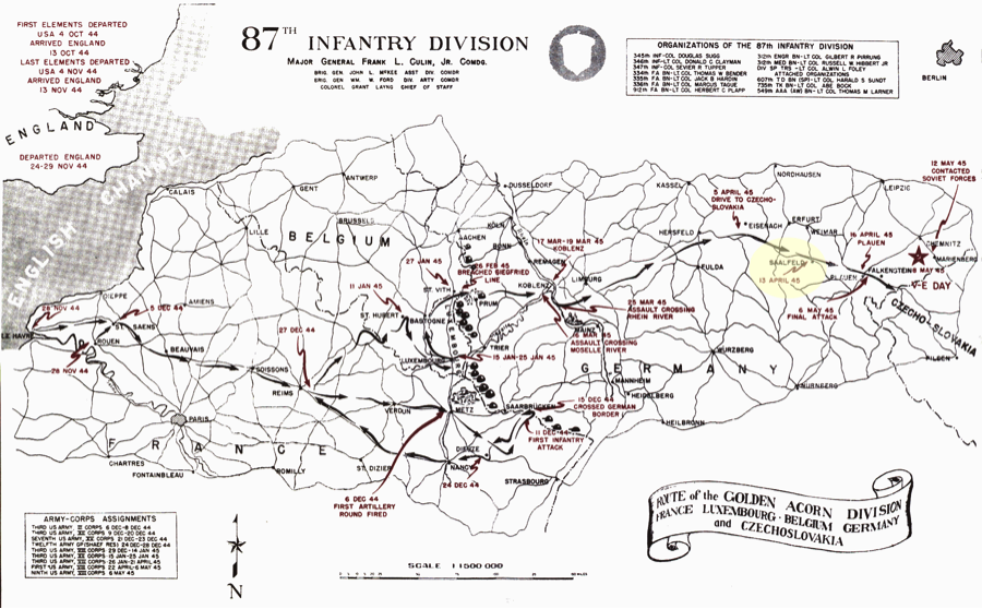
Image 1 – Map of Saalfeld (highlighted in yellow)
The entire geodetic archives of the German army were finally located in a remote warehouse in Saalfeld April 17. Up to 75 truckloads of geodetic data, maps and hand instruments were found. It quickly became apparent to the HOUGHTEAM that they needed some serious help moving all of the materials back to the town of Bamberg. They asked the local artillery unit to assist by providing trucks, and recent German POWs provided the man power. The HOUGHTEAM was also concerned with the advance of Russian troops pushing in from the West. Saalfeld was to be handed over to the Russians as part of their “Zone of Occupation.” Hough knew that the Russians wouldn’t let him keep the rich haul that the HOUGHTEAM discovered. He also feared that they would soon learn that this cache existed and search the entire town for their captured material. Fearing the worst, Hough wrote an expeditious letter to the Chief of Staff, VIII Corps, stating that “in the city of Saalfeld…military personnel is entirely inadequate to cope with the situation which may arrive at any time”(Image 2).
The trucking of material began soon after the arrival of the HOUGHTEAM and was completed on May 28; Russian troops arrived in Saalfeld the very next day. At the time, no one knew whether the Russians were aware that the Americans had made off with all their geodetic holdings. A few years after the war, however, Hough was in Toronto, Canada for an international meeting of geodesists. One of his colleagues introduced him to the leading Russian geodesists, who recently just begun to attend international conferences. One of the Russian delegates said, “We have heard a lot about you, Mr. Hough.”
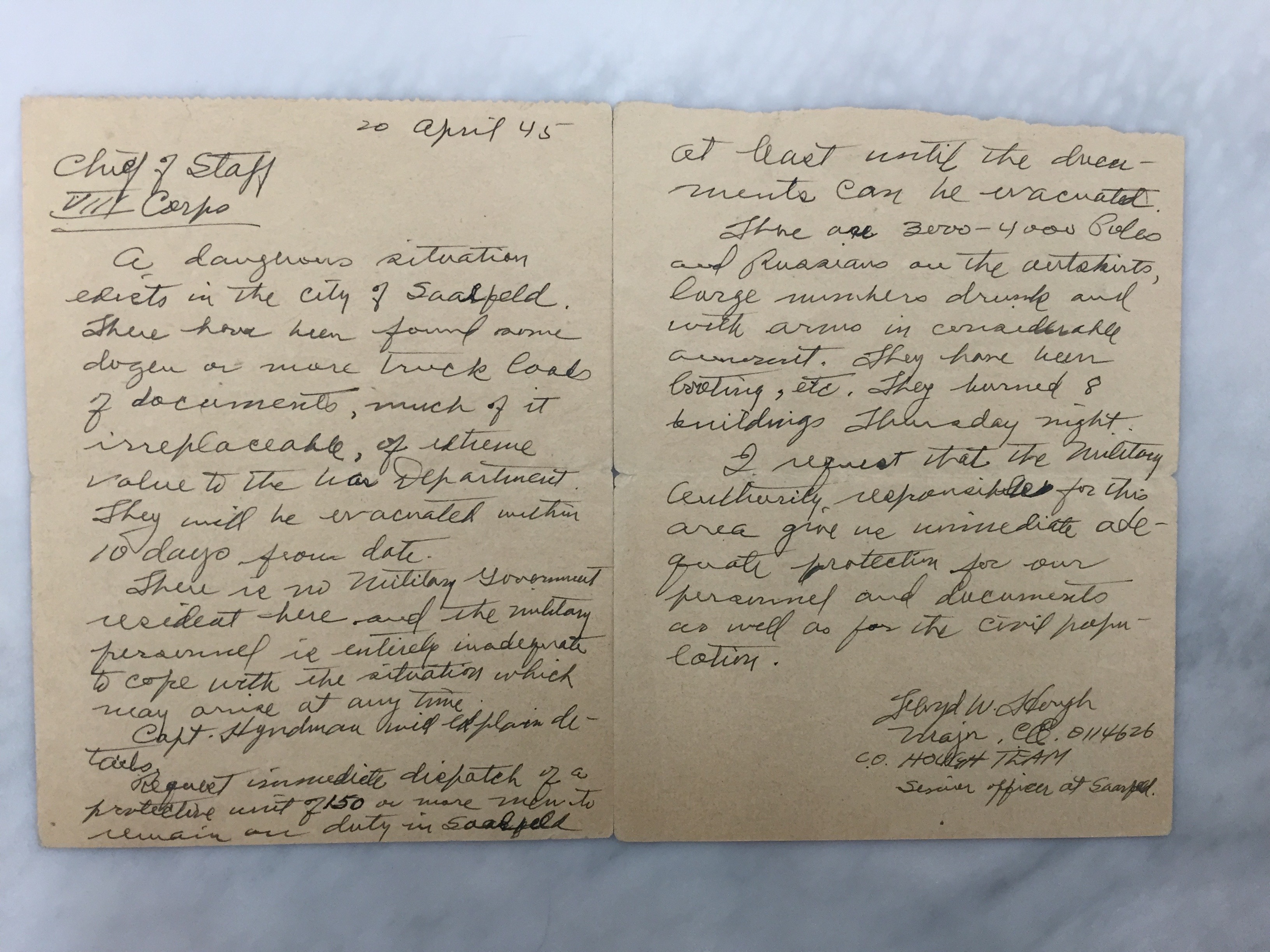
Image 2 – Letter to Chief of Staff (VIII Corps) from Major Hough
Throughout its 11 months of existence, the HOUGHTEAM was able to collect more than 250 tons of material in select cities throughout Germany. One of their more important discoveries was locating the trigonometrical section of the Reichsamt für Landesaufnahme (Reich Office of Recording) in the captured town of Friedrichsroda, Thuringia Province. The German army went to great lengths to conceal their geodetic holdings. Mapping materials were found in such hidden places as remote buildings, caves, and salt mines; buried in earth, sawdust, manure piles, basements, cemeteries, and monasteries; and behind sealed walls. Because the HOUGHTEAM was not issued equipment or the means to haul found and captured material, various artillery units lent the team trucks and small planes during this period. These operations were usually completed in the days prior to Russian occupation. From June to September, the team continued research in Germany and Austria. Individuals were sent to Copenhagen and other western points. One particular individual, the civilian consultant Martin C. Shallenberger, appeared to travel the most. At least once every few weeks Shallenberger would write to Hough, detailing his findings. In one particular letter, Shallenberger wrote about his investigation of the Vatican library. In it, he states that the “library was examined very thoroughly and found to contain no geodetic material of interest.” He continued, “Thus, cloaked in mystery, it had assumed an exaggerated importance as to the strategic military information that it contained.”
In addition to acquiring mapping and geodetic materials, the HOUGHTEAM captured internal mapping agency chiefs who were instrumental in helping the U.S. discover hidden caches. Additionally, the team learned about the leadership hierarchy of the Kriegakarthauptamt, or the War Mapping and Surveying of the German Army. Two prominent members of this organization were located and interrogated by Shallenberger: Colonel Klinkowstroem, assistant chief, and Lieutenant General Gerlach Hemmerich, head of the Kriegakarthauptamt.
During the interrogation of Colonel Klinkowstroem, Shallenberger, the lead interrogator, ascertained that the Germans were performing geodetic preparatory work (third-order surveying) for the areas over Romania, Hungary, Croatia, Slovakia and Bulgaria.This indicated their potential plans for the expansion of German settlements on the Balkan Peninsula.
One interrogation that occurred later than expected was for Lieutenant General Gerlach Hemmerich. After the German army’s surrender on May 7, 1945, many leaders were quickly marshaled and debriefed. However, the general was nowhere to be found. It wasn’t until four months later that his location was finally discovered.
Image 3 – Christmas card from General Hemmerich
On September 15, 1945, Shallenberger was checking into the addresses and homes of former employees of the Deutsche Bank, of which Hemmerich was a director. Initial analysis revealed that general’s home had been taken over as Army quarters; however, he decided to visit the residence on a hunch. Upon arrival, he questioned the female cook and noted that she spoke in pure German, usually only used by highly educated Germans. After intense questioning, he determined that the cook was indeed Frau Hemmerich, wife of the general. She said the general had just started a new job, stoking furnaces for the Americans. He was immediately placed under arrest when he arrived home from work. The general told Shallenberger that he had expected arrest for the past four months.
On top of the capture of several leaders, the Army also netted a number of prominent German geodesists. Among those captured was Erwin Gigas, internationally known chief geodesist of the Reich Office of Recording. Along with his staff and equipment, Gigas was moved to Bamberg, in the U.S. zone of occupation. There, he was instructed to perform least-squares adjustment of a selected network of first-order triangulation, extending over 300,000 square miles of Europe using the HOUGHTEAM’s captured geodetic data. The least-squares adjustment uses all the measurement data, together with control points, to estimate the most probable coordinate for every point in the geodetic network. This was all made possible because each individual country had already performed its own first-order geodetic survey, dictated by national pride of sovereignty. Each datum was typically calculated in the respective country’s capital by establishing an astronomical fix for one station. Tying together all of these individual geodetic networks in the frontier would prove to be a difficult task; a comprehensive project of this type for all of Europe had never before been possible.
This work, under the technical supervision of the Army Map Service, was finally completed in June 1951. The resulting datum is known as the European Datum of 1950, or ED50. It governs all of continental Europe west of 30° East longitude and is computed on the International Ellipsoid. It still is used in much of western Europe, apart from Great Britain, Ireland, Sweden and Switzerland, which have their own datums. During the summer of 1945 at Bamberg, the HOUGHTEAM directed the chief magnetition of the German army to prepare a magnetic atlas of Europe based on a common epoch of 1944-45. This atlas was published by the Army Map Service in 1950.
The HOUGHTEAM returned to the United States and disbanded in late September 1945. The amazing accomplishments of the team during its 11-month mission in Europe may be summarized as follows:
- Obtained complete geodetic data coverage of four provinces of Germany, discovered in the combat area, delivered direct to the artillery and put into an immediate operational use at the front.
- Selected captured enemy material shipped to Army Map Service:
- 202 boxes of geodetic data on 900,000 stations in Europe, giving nearly complete coverage of first, second, third, and fourth control in all German and Allied operational World War II areas of the continent
- 627 boxes of captured maps, covering approximately the same areas noted above (a)
- Large quantities of photograph prints and dispositives for portions of above areas
- 371 boxes of various surveying and photogrammetric instruments, including seven Zeiss stereoplanigraphs
- Geodetic and cartographic library reference books on all countries in Europe.
- Acquisition of a nucleus of German geodesists and mathematicians and their removal to the United States Area of Occupation for use on scientific projects by U.S. forces.
- Technical supervision of the adjustment of European first-order triangulation to a common geodetic datum, ED50.
- The compilation of the magnetic atlas of Europe, epoch 1944-45, published in 1950 by the Army Map Service.
Following the war, Floyd Hough continued on with the Army Map Service, helping develop many other geodetic and mapping projects. One of the more important projects in which he was directly involved was the creation of the Universal Transverse Mercator (UTM) grid, a worldwide plane coordinate system developed in the 1940s by the U.S. Army’s Corps of Engineers. This coordinate system is the father of the current reference system currently in use by the U.S. Armed Forces and NATO, the Military Grid Reference System (MGRS).
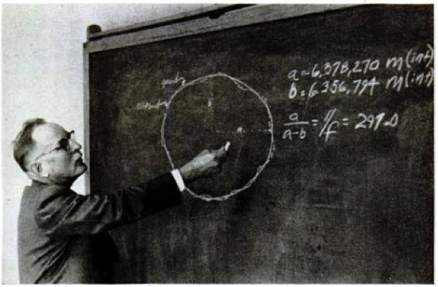
Image 4- Floyd Hough
One of Hough’s more ambitious projects was called the “Figure of the Earth” program.[16] For 14 months in the early 1950s, members of the Army Map Service slowly worked their way across a desolate, 600-mile stretch of Africa. Their goal was to determine the exact size of the Earth and measure precise distances over its curved surface. They chose this remote stretch of land along the 30th meridian because it was the only stretch of land along this line of longitude that had never been measured. Previous measurements along its length had been done in other parts of Africa and Europe. By measuring the entire distance of the 30th meridian, the team would create an excellent “yardstick” to measure the size of the Earth as a whole. They knew that the 30th meridian traverses an exceptionally large amount of land from South Africa up to Norway. Armed with this information, the U.S. would know the exact distance between points across the Earth. These measurements would be paramount in the days of the upcoming missile era.
Soon after the end of the war, civilian mapping agencies in the U.S. showed great interest in the newly discovered mapping and photogrammetric techniques in Germany. During the 1940s and 1950s, several papers were written discussing the German instruments and methods. It was well known that German and Swiss optical and precision mapping-related hardware were of the highest quality.
After his retirement, Hough kept in touch with several geodetic authorities in countries around the world. He was known for encouraging international cooperation and professional friendship. Floyd Hough once wrote, “The term ‘cooperation’ is one of the most satisfying and comprehensive words in the English language. If we were to have complete cooperation in all matters between individuals and nations, the acme of human aspiration would be reached; selfishness would be abandoned; universal peace would be a fact; the millennium would be at hand.”
Floyd W. Hough was awarded the Legion of Merit and the exceptional Civilian Service awards by the U.S. Army in 1957.
Additional contributions by Amber Staicoff (amber.staicoff@gmail.com)
Bibliography
Clarke, K. C., & John, C. G. (2000). On the Origins of Analytical Cartography. Cartography and Geographic Information Science, 195-204.
Dille, J. (1958, May 12). The missile-era race to chart the earth. Life, pp. 124-138.
Dracup, J. F. (2006, June 8). Geodetic Surveying 1940-1990. Retrieved May 18, 2015, from NOAA History: http://www.history.noaa.gov/stories_tales/geod1.html
Fischer, I. K. (2005). Geodesy? What’s That?: My Personal Involvement in the Age-Old Quest for the Size and Shape of the Earth. Bloomington: iUniverse.
Hough, F. W. (1945, April 20). Letter to Chief of Staff, VIII Corps. Saalfeld, Germany.
Hough, F. W. (1945). Materials moved to Bamberg.
Hough, F. W. (1950). HOUGHTEAM. Bethesda: U.S. Army Map Service.
Hough, F. W. (1951). International Cooperation on a Geodetic Project. EOS, Transaction: American Geophysical Union, 106-109.
Kendall, A. (1945, July 21). Letter to Floyd Hough from Chief of Engineers,War Department. Washington, DC.
Shallenberger, M. (1945). Interrogation of PW Klinkowstroem. Bethesda: U.S. Army Map Service.
Shallenberger, M. (1945). Report on Vatican Library. Bethesda: U.S. Army Map Service.
Staff Writer. (1945, September 24). Nazi General found stoking U.S. furnaces, wife a cook. Stars & Stripes.